|
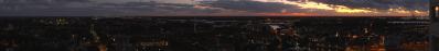
I made several NLC's pano's that night and I would like to show this one too which was shot 13 minutes before my previous pano (25740) but with different photometric settings. If you compare with previous pano, only 13 minutes earlier result in about the same darkness but quite a lot more NLC's much higher in the sky. I measured the NLC's light to obtain the best fine detail, this at the expense of stars and less color in the Terneuzen night skyline. I would like everyone to compare with Winfried Borlinghaus NLC's (pano 25733) too, which was taken at about the same time but accoding to his data 180 km to the south. Our observations prove we saw nearly exactly the same thing although here in Terneuzen a bit higher in the sky!
Canon Eos M6 with EF-M 11-22mm, 15 P RAW, 19mm (30.4 mm KB), iso 400, f 6.3, 1.3 s, 5300°K, PTGuiPro, 28562x3514 404MB TIFF, downsized>1750>1000>500 TIFF>sharpening 4064x500 923KB JPEG
Alvise Bonaldo, Hans-Jörg Bäuerle, Leonhard Huber, Walter Huber, Heinz Höra, Johann Ilmberger, Martin Kraus, Dieter Leimkötter, Wilfried Malz, Steffen Minack, Jan Lindgaard Rasmussen, Arne Rönsch, Björn Sothmann, Jens Vischer
|
 |


Comments
Ciao, Alvise
Dabei bin ich folgendermaßen vorgegangen: Aus der KB-Brennweite ergibt sich für die Einzelbilder ein Höhenwinkel von 40° und aus der Pixelhöhe des Original-Panoramas, daß dieser dort durch Beschnitt nur noch 35° beträgt. Wenn man ins Bild die Horizontlinie in Deichhöhe einträgt, dann ergibt sich für den Abstand zum oberen Rand der NLC's ein Höhenwinkel von 17,8° und den zum unteren Rand von 1,9°. Aus diesen Höhenwinkeln läßt sich für die in 82,5 km Höhe befindlichen NLC's bei Zugrundelegung der Erdkrümmung errechnen, daß sie sich in einer Entfernung von 240 km bis 840 km befunden haben mußten. Das bedeutet für das Zentrum der NLC's mit dem Richtungswinkel von 355°, das sie sich in der Mitte der Nordsee von 53,5° nB, das ist die Breite der nordfriesischen Inseln, bis zu 58,9° nB, das ist ca. die Breite von Stavanger in Südnorwegen, erstreckt haben. Aus den Richtungswinkeln 315° = NW und 45° = NO zwischen denen die abgebildeten NLC's liegen, ergibt sich, daß sie sich bei ihrer mittleren Entfernung von O nach W über die gesamte Nordsee von der englischen Küste bei Newcastle upn Tyne bis weit über Schleswig-Holstein erstreckt haben mußten. Insgesamt kann man also sagen, das die im Panorama zu sehenden NLC's über dem gesamten Bereich der Nordsee von W nach O und fast den fesamten von S nach N erstreckt haben mußten.
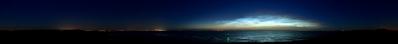
To check the area and the farthest distance of the NLC's ( these just above the horizon), I made a pano with UDeuschle in northern direction from 315° to 45° and with my camera at an elevation of 80000 m above the dike. Although the program limits the max range of sight to 750 km, it calculated the farthest point at 753 km in Norway. At left on the horizon, we have the Scotland heights and on the right Southern Norway. So yes Heinz is right, the farthest NLC's on the pano are 600-800 km away and given the orientation, they covered the whole North Sea. I will post another interesting NLC's observation soon, shot at 1:10 our time (23u10 UTC), so when the sun is near deepest behind the horizon.
UDeuschle test pano:
https://www.udeuschle.de/panoramas/panqueryfull.aspx?mode=newstandard&data=lon%3A3.83802%24%24%24lat%3A51.3359%24%24%24alt%3A80000%24%24%24altcam%3A1%24%24%24hialt%3Afalse%24%24%24resolution%3A20%24%24%24azimut%3A360%24%24%24sweep%3A90%24%24%24leftbound%3A315%24%24%24rightbound%3A45%24%24%24split%3A60%24%24%24splitnr%3A2%24%24%24tilt%3Aauto%24%24%24tiltsplit%3Afalse%24%24%24elexagg%3A1.2%24%24%24range%3A750%24%24%24colorcoding%3Afalse%24%24%24colorcodinglimit%3A753%24%24%24title%3Anlc%24%24%24description%3A%24%24%24email%3A%24%24%24language%3Aen%24%24%24screenwidth%3A2515%24%24%24screenheight%3A1417
I find your proposal to use UDeuschle for a view from 80 km above sea level very interesting. But one should not do this with the coordinates of terneuzen, but from the edges of the visible NLC's over the North Sea calculated by me. The UDeuschle views determined in this way then reflect the area on earth from which one would have to be visible these edges of the NLC's.
Here are the links to the UDeuschle views determined in this way:
https://www.udeuschle.de/panoramas/panqueryfull.aspx?mode=newstandard&data=lon%3A3.8%24%24%24lat%3A58.9%24%24%24alt%3Aauto%24%24%24altcam%3A82500%24%24%24hialt%3Afalse%24%24%24resolution%3A20%24%24%24azimut%3A180%24%24%24sweep%3A180%24%24%24leftbound%3A90%24%24%24rightbound%3A270%24%24%24split%3A60%24%24%24splitnr%3A3%24%24%24tilt%3A-12.0833333333333%24%24%24tiltsplit%3Afalse%24%24%24elexagg%3A1.2%24%24%24range%3A900_grid%24%24%24colorcoding%3Afalse%24%24%24colorcodinglimit%3A130%24%24%24title%3ANLC-Position%3A%2082%2C5km%20ueber%20noerdlicher%20Nordsee%24%24%24description%3A%24%24%24email%3A%24%24%24language%3Age%24%24%24screenwidth%3A1280%24%24%24screenheight%3A933
https://www.udeuschle.de/panoramas/panqueryfull.aspx?mode=newstandard&data=lon%3A3.8%24%24%24lat%3A53.5%24%24%24alt%3Aauto%24%24%24altcam%3A82500%24%24%24hialt%3Afalse%24%24%24resolution%3A20%24%24%24azimut%3A180%24%24%24sweep%3A180%24%24%24leftbound%3A90%24%24%24rightbound%3A270%24%24%24split%3A60%24%24%24splitnr%3A3%24%24%24tilt%3A-11.875%24%24%24tiltsplit%3Afalse%24%24%24elexagg%3A1.2%24%24%24range%3A900_grid%24%24%24colorcoding%3Afalse%24%24%24colorcodinglimit%3A130%24%24%24title%3ASuedlicher%20Rand%20NLC-Position%3A%2082%2C5km%20ueber%20Nordsee%24%24%24description%3A%24%24%24email%3A%24%24%24language%3Age%24%24%24screenwidth%3A1280%24%24%24screenheight%3A933
The fact that practically usable views can be generated with such extreme values testifies to how forward-looking Dr. Deuschle programmed his tool.
However, I would like to point out once again that the observation points I have selected in their examples at an altitude of 82.5 km show exactly the southward area on earth from which one should be able to see this part of the NLC. In the conjective, it should be noted, then also the angular areas and those they can be seen and under which they are made to glow by the sun, must be observed. However, UDeuschle also provides a help for this, because at the abscissa the elevation angles for the places or areas on the earth are indicated.
Leave a comment