
| Cycle through labels: |
|
| Björengletscher |
| Mount Forel 3360m |
| Fruejberg 3000 m ? |
| Forelporten ? |
| Jura Gletscher |
| Bredekuppel 2800 m ? |
| Paris Gletscher |
|
||||||||||||||||||||||||||||||||||
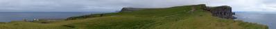
The flight LH446 took me from Frankfurt to Denver. We flew quit far north since there was a low pressure system over Island (I did not even see a tiny bit of the island). Entering Greenland we passed a few fjords on the right-hand side and came across the last mountain tops a few minutes later. The view goes southward; the plain was moving approx. NE to SW. The horizon (the sea) was completely under a cloud cover (hence I removed it from the picture), dry air over the central ice-cap freed the nunatakers framing the huge glaciers free from mist and moisture.
Within the last one or two days it was possible for me to more the less pinpoint my position I hope I am right; I will take up alternative suggestions with pleasure. I know the entrance trajectory of the plain over Greenland from taking a picture of the on-board information system after taking these pictures (I did not use my GPS and the exact flight path in unfortunately not longer available on the inter-net). Consequently I know that we flew in over King Christian IX land and comparing the land cover you can see with different maps and udeuschle models I came to the conclusion that we look at the northernmost part of Schweizerland with the Paris Gletscher and the Mount Forel group one of the highest mountain tops in Greenland. As already mentioned, I am open to alternative suggestions; my localization attempt is just an educated guess I think this is the first Greenland picture on pp. For further reference see the following links: MAPS http://www.aus-sicht.ch/images/Groenland/Schweizerland.pdf http://www.aus-sicht.ch/images/Groenland/Buch_Karte_Weber.pdf SATTELITE IMAGE Mount Forel http://www.satelliteviews.net/cgi-bin/w.cgi/?c=gl&UF=-2081867&UN=-2889241&DG=MT UDEUSCHLE-surface model the region we are looking at is around 170°-175°: http://www.udeuschle.selfhost.pro/panoramas/panqueryfull.aspx?mode=newstandard&data=lon%3A-36.93604%24%24%24lat%3A67.29467%24%24%24alt%3Aauto%24%24%24altcam%3A10000%24%24%24hialt%3Afalse%24%24%24resolution%3A40%24%24%24azimut%3A180%24%24%24sweep%3A60%24%24%24leftbound%3A150%24%24%24rightbound%3A210%24%24%24split%3A30%24%24%24splitnr%3A2%24%24%24tilt%3A-10%24%24%24tiltsplit%3Afalse%24%24%24elexagg%3A1.2%24%24%24range%3A300%24%24%24colorcoding%3Atrue%24%24%24colorcodinglimit%3A303%24%24%24title%3ANunataker%24%24%24description%3A%24%24%24email%3A%24%24%24language%3Age%24%24%24screenwidth%3A1280%24%24%24screenheight%3A994 TOURISTIC INFO http://www.climbgreenland.com/index.php?id=1644 Technical stuff: 5 HF RAWs, 15:20 local time, f/9, 70 mm, crop to 1/3 of picture height (= approx 200 mm equals approx 300 mm KB). Processing: DPP, Hugin, Gimp |
||||||||||||||||
|
|||||||


Comments
Eine gigantische Landschaft, der Großteil wahrscheinlich bis heute der Menschheit unbekannt, da von Eis bedeckt. Zudem eine gute Vorstellung, wie es bis vor 10.000 Jahren in den Alpen ausgesehen hat.
Zur Verifizierung des Standortes verweise ich auf diverse Flugroutendatenbanken wie z.B. http://de.flightaware.com oder www.flightradar24.com - dort können auch "historische" Flüge unter Angabe von Datum und Flugnummer nachverfolgt werden.
Beste Grüße,
J
Muss eine wahnsinnige schöne Landschaft da unten sein.
Interessante Aufnahmen.
lg Patrick
LGC
Es grüßt Wolfgang
Herzliche Grüße, Matthias.
Aber bitte wie kommt man(n) auf so was ???
Vielleicht kann ich damit wirklich noch den einen oder anderen Berg benennen ....
http://www.panorama-photo.net/panorama.php?pid=9343
Unfortunately it is labelled wrong, as was it from Denmark. Also, from a small research I seem to have dias of the same nunataks as you - I just can't make a pano of it:-)
LG Jan.
Es ist unmöglich, jenen Obergabelhorn + Wellenkuppe kurz hinter dem Mount Forel nicht erkennen!
Herzlichst
Hans-Jörg
Leave a comment