|
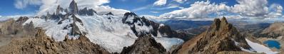
This view from Maja Rosit / Rosni Vrh encompasses both N.13825 and N.13946. It has been shot few minutes before both of them.
Few hours after the upload of the present work (what a coincidence!), I received a mail from Ahmet Rekovic, of the Plav mountaineering club, in answer to a request for topographical help that I had sent him few days before. Namely, the identification of the summits was very difficult due to the unreliability of the Udeuschle data and the lack of serious cartography.
Now the labels up to Maja Rogamit are set according to the annotated version of of N.13825 which he sent me with incredible kindness.
So, the "cursed mountains" of the Prokletije will finally have reliable names - which, he guarantees, are hard to retrieve even for a local!
28 vertical images, 70 mm (x 1.5), 1/320 sec, f/8.
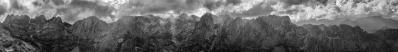
For interested people there are further resources, namely
- larger colour panorama: goo.gl/vje8Nx
- larger BW panorama: goo.gl/vje8Nx
- rendering vs. reality: goo.gl/n8XzPM
- an embedding 360°: goo.gl/l0HNlT
- the GPS track with the traverse that allowed me to climb Maja Jezerces and Maja Rosit in a single day: www.wikiloc.com/wikiloc/view.do?id=5582913
|
 |


Comments
With two trekkers that I met in situ during three August days, and one fan also here, the Prokletije (which is said to be the most impressive mountain group in Europe outside the Alps) confirms its magnetic attraction!
I guess that what we see is sand, presumably also eroded by the wind from the nearby walls. Namely, close to grassy spots the snow is remarkably cleaner:
picasaweb.google.com/albertopedrotti/Balcani_2#5923601062570577218
Under the rocks,on the other hand, it is always very dirty.
Here you find a closeup of the snowfields below those that you are mentioning:
www.panoramio.com/photo/97380191
Here is the larger snowfield that I found, on the other side:
www.panoramio.com/photo/95840814
Here is the snowfield behind the two Kolatas:
picasaweb.google.com/albertopedrotti/Balcani_2#5923601772841258258
Greetings,
Alberto.
Leave a comment