
| Cycle through labels: |
|
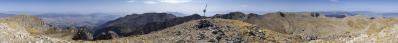
| Montagne de Peyssier 1565 m |
| Vieux Chaillol 3163 m, 61 km |
| L'Ailefroide 3954 m, 81 km |
| Le Sirac 3440 m, 71 km |
| Serre Soleille 1192 m |
| Pointes de Rougnoux 3179 m, 70 km |
| Méouge |
| Grande Autane 2782 m |
| Buëch |
| Upaix |
| Les Croix 1425 m |
| Les Chanderettes 1551 m |
| Roche Cline 1718 m |
| Grande Gautière 1825 m |
| Pointe d'Eyrolle 1754 m |
| Dormillouse 2505 m, 49 km |
Sommerfarben, an die man sich gewöhnen könnte.
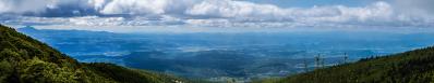
Nach dem Aufstieg zum Pic Saint-Cyr ist dieses Pano am Parkplatz des Talorts Antonaves aufgenommen worden. Gipfelpano unter http://www.alpen-panoramen.de/panorama.php?pid=15406 5 QF-Aufnahmen, 45 mm KB |
||||||||||||||||
|
|||||||


Comments
Hattest du gestern an dieser Stelle mal kurz ein Schwarzwald-Pano hochgeladen? Da wollte ich schon etwas Kritisches schreiben, aber offenbar hat es dich auch nicht ganz überzeugt...
Saubere Detailschärfe!
Gruss Walter
Leave a comment