|
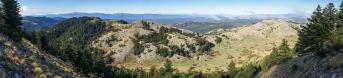
Nach den Tagen an der Küste wollte ich weiter ins Landesinnere Montenegros. Auf dem Weg ergab sich eine spannende Halbtageswanderung zum Velji Vrh (1277m). Die Rundsicht vom flachen Gipfel fügt den zuletzt gezeigten Bildern aus dem Orjen Gebirge wenig hinzu, was hier für Interesse sorgen könnte. Daher ein Bild von unterwegs, genauer vom Abstieg. Immer noch geht der Blick auf die Bucht von Kotor.
Bemerkenswert sind die bis zum Gipfel führenden, gemauerten k.u.k Militärwege, angelegt um 1900, jetzt teils zugewachsen, aber immer noch ein bequemer Weg durch Karst und Felsen. Irgendwo lag auch eine größere Schlange mitten auf dem Weg, ich hab sie glücklicherweise nicht geweckt.
Etwas mehr zur Umgebung auf https://de.wikipedia.org/wiki/Crkvice - demnach ist das auch die niederschlagsreichste Ecke Europas - da hatte ich wohl Glück.
After spending a few days on the coast, I wanted to head further inland into Montenegro. On the way, I went on an exciting half-day hike to Velji Vrh (1,277 m). The panoramic view from the flat summit adds little to the pictures I recently shared from the Orjen Mountains that might be of interest here. So here’s a photo taken along the way – more specifically, on the descent, still with a great view on the Bay of Kotor.
Worth noting are the stone-paved Austro-Hungarian military paths leading up to the summit, built around 1900; they’re now partly overgrown but still provide a comfortable route through the karst and rocky terrain. At one point, there was also a rather large snake lying right in the middle of the path – fortunately, I didn’t disturb it.
A bit more about the area at https://en.wikipedia.org/wiki/Crkvice,_Montenegro – apparently, this is also the rainiest corner of Europe – so I suppose I was lucky.
Olympus OM-D E-M5 III
M.Zuiko 12-45/4 Pro @16mm (32mm KB)
10 HF RAW freihand, ISO 200, 1/800, f8
Lightroom Classic CC, Autopano Giga 4.4.2, IrfanView
Direktlink auf Google Maps: https://maps.app.goo.gl/zqGb2ewbnNRbKD6G8
Hans-Jürgen Bayer, Peter Brandt, Jörg Braukmann, Hans-Jörg Bäuerle, Günter Diez, J. Engelhardt, Jochen Haude, Lukas Klös, Dieter Leimkötter, Wilfried Malz, Jörg Nitz, Danko Rihter, Arne Rönsch, Silas S, Björn Sothmann, Konrad Sus, Arjan Veldhuis, Jens Vischer, Benjamin Vogel
|
 |










Comments
LG Jörg
Einen guten Start in die neue Woche und herzliche Grüße,
Hans-Jörg
Das mit dem Niederschlag hätte ich übrigens nicht gedacht, hätte da eher auf Norwegen getippt.
Gruß
Lukas
Grüße
Dieter
Leave a comment