|
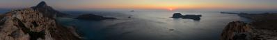
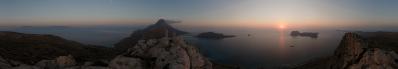
Gramvoussa is the last of the three prominences at the NW edge of the island of Crete.
The first one, Akrotiri, hosting also the Chania airport, is the thickest and comparatively less interesting.
The second one, Rhodopou, is rather wild and can be approached only via a dirt road where it is highly recommended to have a strong bicycle or a 4WD.
Gramvoussa has also a dirt road as an access, but it is fairly shorter and more accessible. Few kms after a building where one is required to pay a symbolic 1-euro fee, the road ends at a parking which is also the start of four paths.
99% of the people take the 20-min path down to the "Caribbean-style" Balos beach, where they mix with the hundreds of people carried by the daily cruises from Kastelli-Kissamos to Balos-Gramvoussa. The remaining 1% divide between a path leading to a cave and one leading to a church with annexed ruins of an ancient temple, the Agneion. 0% follow the wonderful 5 km path to Cape Vouxa. I do not count as a fifth path the highly adventurous 9km track coming from Phalasarna, since it gets lost among the vegetation well before arriving to the Balos zone. It is possible (but not straightforward) to find and to follow it only starting from its Phalasarna end.
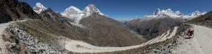
The present photograph is taken from a 234m elevation lying aside the Cape Vouxa path, which has to be left maybe 20-25 min from the parking, pointing leftwards to a visible little column.
Two islands very close to the coast bear the name of Gramvoussa. With a curious toponomastic arrangement that is found also in the Alps, we have a mild (Imeri) and a wild (Aghria) Gramvoussa, the former hosting - on the top of its perfectly trapezoidal shape - a Venetian fortress, the latter completely deserted except for the presence of a lighthouse.
Sebastian Becher, Klaus Brückner, Hans-Jörg Bäuerle, Volker Driesen, Gerhard Eidenberger, Jörg Engelhardt, Jannis Gligoris, Thomas Hansen, Leonhard Huber, Heinz Höra, Marius Klein, Martin Kraus, Daniel Mürbe, Jan Lindgaard Rasmussen, Danko Rihter, Patrick Runggaldier, Arne Rönsch, Werner Schelberger, Udo Schmidt, Christoph Seger, Markus Ulmer, Robert Viehl, Jens Vischer, Alexander Von Mackensen, Augustin Werner, Beatrice Zanon
|
 |


Kommentare
Fantastic lightening, this applies particularly the stones on the left and right sides...
Regards,
Jörg E
The photos were seven, 1/60 sec, f/4.5, ISO 640, and I had to use the 16-85 right at 16 in order to have at the border of each shot some slice of land for the sake of control points...
Kommentar schreiben