|
Kingston is a town located in Eastern Ontario where the St. Lawrence River flows out of Lake Ontario near the Thousand Islands. Strategically located midway between Toronto and Montreal, Kingston was named the first capital of the Province of Canada on February 15, 1841. While its time as a political centre was short, Kingston remained an important military installation.
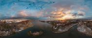
The Thousand Islands are an archipelago of islands that straddle the Canada-U.S. border in the Saint Lawrence River as it emerges from the northeast corner of Lake Ontario. They stretch for about 50 miles (80 km) downstream (i.e. east) from Kingston, Ontario.
Wolfe Island Islands is the largest of the Thousand Islands and can be reached by ferry from both Canada and the United States.
The Wolfe Island Wind Project, a wind farm developed by Canadian Hydro Developers, is a 198 MW wind plant consisting of 86 wind turbines and has been in commercial operation since June 2009. It is currently the second largest turbine project in Canada.
The original Fort Henry was constructed during the War of 1812, when present-day Ontario was a British colony known as Upper Canada. The British anticipated the possibility of a United States attack. The present Fort Henry was constructed between 1832 and 1837. At the time, these fortifications were the strongest defences in Canada west of Quebec City. Neither the original nor the second Fort Henry was ever attacked.
(source: Wikipedia)
Technisch nicht perfekt, aber meiner Meinung nach eine doch recht schoene Aufnahme von einem interessanten Standort:
8 freihaendige Aufnahmen bei Brennweite 28mm im Querformat.
Gestitcht nach ein paar Anlaeufen mit Hugin.
Aus Gruenden, welche mir nicht klar sind, hat das Stitchen hier einiges an Kopfzerbrechen bereitet. Schliesslich es mir mit Hugin am besten gelungen, den See einigermassen horizontal hinzukriegen, aber ich habe auch hier noch am Schluss ein paar Stitchingfehler ausbessern muessen.
|
 |


Kommentare
Kommentar schreiben