
|
|||||
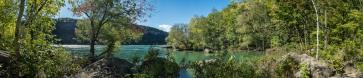
For those who like my last panorama of the Welland Canal, here's a recent capture of remains of the 2nd historical Canal. By Ontario standards these are very structures, built before 1850, are really old and ancient structures, but seemingly a underappreciated and a bit neglected.
I never knew about them until my son moved to a house right in this neighbourhood. 2ND WELLAND CANAL - 1845 - 1915 "With the growing use of the Welland Canal, and ships getting bigger, a new larger canal was needed. The Second Welland Canal consisted of 27 locks and was used until 1881, although the canal itself continued to be used for local transportation of goods and power until around 1915. The Second Welland Canal followed mostly the same route as the First Welland Canal, changing the wooden locks to those made of limestone. Entering in through Port Dalhousie, up the Twelve Mile Creek and then turned at Dick's Creek. There is actually a lot of the Second Welland Canal to be found as most of it is used as an open air sewer system today. Many of the 27 locks are intact and visible." Source: http://wellandcanals.ca/ 12 handheld captures in portrait orientation. 14mm M43 = 28mm KB
Gefällt
7 Mal
|
||||||||||||||||
|
|||||||


Kommentare
Herzliche Grüße
Hans-Jörg
Kommentar schreiben