
| Durchlauf: |
|
| Kalpaki (1336m, 60km) |
| Vrizacha (1613m, 57km) |
| Ghravia (1070m) |
| Vroupista (1154m) |
| Oxya Road (Pano #26826) |
| Korilas (1658m, 58km) |
| Chionistra (1643m, 55km) |
| Vikos Gorge |
| Psilo Vouno (956m, 66km) |
| Profitis Ilias (1004m, 46km) |
| Soutista (1329m, 30km) |
| Megalo Soremadi (1318m) |
| Vouna Veladilas (1057m, 48km) |
| Igoumenitsa |
| Varathro (640m, 64km) |
| Velouna (1201m, 43km) |
| Farmakovouni (1240m, 51km) |
| Profitis Ilias (950m, 55km) |
| Filiaton (1064m, 53km) |
| Skitari (1401m, 36km) |
| Mavrovouni (1749m) |
| Mourgana (1806m, 39km) |
| Maja Vertopit (1524m, 45km) |
| Roki (1726m, 43km) |
| Chionades (1759m, 43km) |
| Michalakadhes (849m, 84km) |
| KORFU |
| Pantokrator (903m, 81km) |
| Maja Kakos (1296m, 49km) |
| Saranda |
| Maja Orianas (1160m, 45km) |
| Maja Muzines (1155m, 47km) |
| Othoni - Imerovigli (393m, 119km) |
| Maja Frashtanit (1037m, 47km) |
| Maja Prosilit (1221m, 50km) |
| Koutsokrano (1325m, 26km) |
| Maja Leftakares (1230m, 51km) |
| Maja Bidos (1547m, 55km) |
| Maja Nikollasit (1584m, 55km) |
| Maja Makrigimit (1601m, 58km) |
| Maja Luces (1833m, 71km) |
| Maja e Keshajit (1770m, 61km) |
| Maja Fresharit (1789m, 62km) |
| Maja e Çikës (2045m, 100km) |
| Ceraunian Mountains |
| Maja Qores (2018m, 103km) |
| Maja e Qiramanges (1830m, 104km) |
| Maja Lepushes (2045m, 47km) |
| Maja e Lalucit (2155m, 48km) |
| Dousko (2207m) |
| Maja Fanjas (2356m) |
| Nemercke |
| Maja Kourouna (1852m) |
| Maja e Drites / Papingut (2482m, 33km) |
| Maja e Trebeshines (1923m, 70km) |
| Aoos River |
| Grenze Griechenland - Albanien |
| Aetopetra |
| Melissopetra |
| ALBANIEN |
| Maja Qarrishtes (1291m, 59km) |
| Maja Postenanit (1554m, 33km) |
| Maja Taborit (1572m, 50km) |
| Maja e Tomorit (2310m, 91km) |
| Maja e Partizanit (2416m, 98km) |
| Maja Qelqit (1663m, 53km) |
| Lapatos (2251m) |
| Maja Faqekuqit (2352m, 69km) |
| Maja e Ostrovice (2383m, 71km) |
| Maja Ostrovices (2347m, 73km) |
| Maria / Maja Vashes (1637m, 21km) |
| Maja e Valamares (2373m, 95km) |
| Kamenik (2042m, 27km) |
| Saradaporos River |
| Maja Pelzes (2178m, 38km) |
| Mavri Petra (2450m, 41km) |
| Ghramos - Tsouka Petsik (2521m, 42km) |
| Perifano (2444m, 41km) |
| Kiafa (2395m, 42km) |
| Epano Arena (2196m, 39km) |
| Trapezitsa (2024m) |
| Kato Arena (2085m) |
| Klefti (1847m) |
| Roidhovouni (1977m) |
| Drakolimni (2000m) |
| Ntaliopoulo (2217m) |
| Misorachi (2217m) |
| Smolikas (2631m, 19km) |
| Mosia (2600m) |
| Ploskos (2380m) |
| Gamila (2497m) |
| Karteros (2478m) |
| Megala Litharia (2424m) |
| Goura Tsouka (2467m) |
| Samari (2297m) |
| Milia (2159m, 37km) |
| Flega (2157m, 32km) |
| Zighos (1820m, 43km) |
| Kalambaka / Meteora |
| Kisa (1652m, 75km) |
| Tsouka Rossa (1985m, 25km) |
| Voulgharis (1822m, 44km) |
| Metsovo |
| Spano (1608m, 78km) |
| Kousta (1729m) |
| Trigia (2204m, 65km) |
| Nereidha - Batis (1958m) |
| Nereida - Britsiasa (2135m, 69km) |
| Stakokola (2045m, 44km) |
| Loupata (2060m, 79km) |
| Kazarma (1597m, 17km) |
| Peristeri - Tsoukarela (2294m, 44km) |
| Katarachias (2280m, 55km) |
| Gourasa (2185m, 43km) |
| Kakarditsa (2429m, 62km) |
| Rouista (2254m) |
| Priza (2047m, 48km) |
| Kriakouras (2158m, 67km) |
| SÜDLICHER PINDOS |
| Tzoumerka - Gherakovouni (2364m, 65km) |
| Avgherinos (1706m) |
| Tzoumerka - Katafidhi (2393m, 68km) |
| Korfoula (1643m, 109km) |
| Profitis Ilias (1584m, 111km) |
| Chelona (1538m, 104km) |
| Erymanthos (239km, nicht sichtbar) |
| Mitsikeli - Kaminia (1740m) |
| Xerovouni (1655m, 67km) |
| Ghorghomilos (1472m, 77km) |
| Boumistos (1577m, 140km) |
| Akarnaniki - Psili Korifi (1588m, 136km) |
| Preveza |
| Tsouka (1595m) |
| Tomaros - Seloma (1971m, 53km) |
| Zagori |
| Metsitia (1286m, 75km) |
| Apokrimno (1002m, 79km) |
| Lefkada |
| Stavrotas (1182m, 142km) |
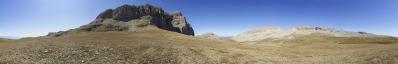
Nach dem Pano vom Aufstieg ist natürlich die Aussicht vom Gipfel fällig. Blickfang sind hier insbesondere die nordöstliche Kette des Tymfi Gebirges mit der Gamila als Höhepunkt, sowie jenseits davon der Smolikas, unser Ziel für den nächsten Tag. Schön sichtbar auch der Drachensee "Drakolimni", das hier beliebteste Wanderziel, das wohl einen besonderen Blick in die steile Gamila Nordwand bietet.
After the pano from the ascent, the view from the summit is of course due. Eye-catchers here are especially the northeastern chain of the Tymfi mountains with the Gamila as the highlight, and beyond that the Smolikas, our destination for the next day. The dragon lake "Drakolimni", the most popular hiking destination in the area, which offers a special view into the steep Gamila north face, is also nicely visible. Olympus OM-D E-M10 M.Zuiko ED 40-150 @ 53mm (=106mm KB) 95 HF RAW freihand mit Standortwechseln, ISO 200, 1/400, f11 Lightroom CC, Autopano Giga 4.4.2, IrfanView 360° Blickwinkel Direktlink auf Google Maps: https://goo.gl/maps/4TYqr1VNaQRbcMRK9 Die Beschriftung in Griechenland ist rechercheintensiv, da udeuschle wenig Labels hat und peakfinder mitunter falsche, aus OSM interpolierte Höhen und ich immer mit topoguide.gr abgleiche. Was mir nicht klar ist, warum die sehr präzise topoguide.gr Karte (vom Anavasi Verlag, der auch hervorragende Wanderkarten produziert) immer delta als dh und gamma als gh transkribiert. Wenn ich Namen und Höhen dort übernehme, dann auch die Transkription. Für den albanischen Teil übernehme ich aus peakfinder.org.
Gefällt
21 Mal
|
||||||||||||||||
|
|||||||


Kommentare
Lass Dir Zeit mit der Beschriftung, die nächsten Tage wird dazu zu Hause sicher ausreichend Gelegenheit sein...
@HJB...und wenn es nicht das Beste ist, dann ist auch noch nicht Schluß! :-)
VG, Danko.
DANKE auch für die Mühe mit der ausführlichen Beschriftung, die mich heute morgen nochmals in aller Ruhe zum schauen und studieren des großartigen Werkes animiert hat !!!
Ein herzlicher Gruß vom Schwarzwald an den Taunusrand,
Hans-Jörg
Eine wunderbare Rundsicht nicht nur für Fernsichtfreunde!
LG Jörg
Kommentar schreiben