Camargue   151146
previous panorama
next panorama

Labels

Details

Location: Sainte-Marie-la-Mer (near)      by: Giuseppe Marzulli
Area: France      Date: 4 April 2015
SOLVED RIDDLE.

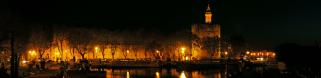
I think the Camargue does not need particular explanations.
With an area of over 930 km2 the Camargue is western Europe's largest river (Rhône) delta.
It is a vast area, perhaps a bit monotonous, but of great naturalistic interest.

Comments

This is not easy. However I would suggest somewere around Venezia or the Po - if it is Italy …
2019/09/17 20:13 , Christoph Seger
It's really not easy. To make matters worse, I currently have only the mobile available. At first glance, I think it could be the lagoon of Venice, Grado or the delta of Po, but the shallow access to the water and this fence irritate me. I haven't seen that in this way yet. What does this fence protect? Salt? Is it possible that you are not in Italy? Maybe in France, in the Camargue?

Cheers Werner
2019/09/17 20:18 , Werner Schelberger
@ Christoph & Werner ...
I was on the same path - but I gave up last night. In my opinion a typical French construction of the fence - or a French import to Italy ;-) ... Giuseppe, your riddles are getting more and more complicated :-) !!!
2019/09/17 20:44 , Hans-Jörg Bäuerle
It is not in Italy.
2019/09/17 20:45 , Giuseppe Marzulli
I think also about France. May be Normandy. However it's a pretty picture of a pretty landscape.
LG Jörg
2019/09/17 21:23 , Jörg Nitz
France. But where?
2019/09/17 22:05 , Giuseppe Marzulli
Vanlée - Normandy?
There is a similiar picture from you in 2009.
2019/09/18 08:23 , Werner Schelberger
No. Your first hypothesis was good.
Let's see if anyone finds the exact location.
2019/09/18 10:13 , Giuseppe Marzulli
48,940897, -1,554410 ?
2019/09/18 12:17 , Hans-Jürgen Bayer
Der Zaun 
Could it be that the fence is dividing a special area of the Biosphere Reservation Area of the Camargue? There is a sign in the left and a building on the right, witch seems to be a official building. The direction of the Pano is to the north.
2019/09/18 19:03 , Christoph Rhein
Surely you are on the right track. However, I'm not sure that you have found the right place, because some years have passed and my memories are not precise. Could you give me the coordinates?
2019/09/18 19:34 , Giuseppe Marzulli
this is really bretteleben …
2019/09/20 17:47 , Christoph Seger
I will try it again. There is a sign in the left - ok - and a building on the right, which seems to be a official building. Is it really a building or could it be also a camper? Directly at this point there is a culvert to control the water-level. In the middle of the Panorama there could be a town at the horizont and leftside from this town at the headland could be a tower. So I try to solve:
CJW9+P4 Arles, Frankreich (43.4468253, 4.6177796)

Cheers Werner
2019/09/23 12:53 , Werner Schelberger
WHOW - appreciated !!!
2019/09/23 19:27 , Christoph Seger
Hi Werner. Thank you very much for your effort. There were no buildings on the right or on the left, but only campers.
But the truth is that I don't remember the point exactly.
With certainty, I can only say that I was on the road between Saintes-Maries-de-la-Mer and the Salin-de-Giraud and that therefore the position indicated by you is the right one.
Congratulations.
I'll arrange everything tomorrow.
2019/09/23 22:42 , Giuseppe Marzulli

Leave a comment


Giuseppe Marzulli

More panoramas

... in the vicinity  
... in the top 100