|
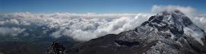
Kedarnath is actually the third of the 4 Char Dhams. As I didn't get proper Panos on spot 1 and 2 this is the first Dham you can see here. Kedarnath is situated amidst some of the highest mountains of the Garhwal Himalayan Range, which reach above 7000m. Unfortunately only a few glacier and snow covered slopes became visible, otherwise just clouds, clouds, clouds. Because of it's high location the temple and the village are only open from April to October. Everybody moves to lower places in winter. Kedarnath is one of the most holy shrines of Lord Shiva and the famous saint Shankara passed away here many centuries ago. Surrounding the village are lots of small huts and shelters, where sadhus (Hindu hermits and wandering monks) are staying. They are chanting mantras and smoking chillums (made from the Marihuana plants that grow everywhere like weeds) and live from almost nothing, only getting occasional alms from the pilgrims. To reach Kedarnath one has to do a 14 km trek from Gaurikund, which is the end of the motorable road. Most pilgrims, however, take ghoras (pony like horses or palkis (chairs with 4 handles, carried by local porters) for their journey. In recent years helicopters are available, too.
|
 |


Kommentare
Kommentar schreiben