|
Fortsetzung einer jahresübergreifenden Serie am Ziria Massiv. Bei der Wanderung zum höchsten Gipfel (auch Kyllini) war mir im November 2016 schon der "kleine" Ostteil jenseits des Flambouritsa Tals als attraktives Bergziel aufgefallen. Da gutes Wetter vorhergesagt war, nahm ich dieses Ziel dann gleich für den ersten vollen Tag der diesjährigen Reise in Angriff. Von meinem Quartier direkt am Meer in Xylokastro fährt man auf schöner, kurviger Straße in einer Dreiviertelstunde ins Bergdorf Kefalari.
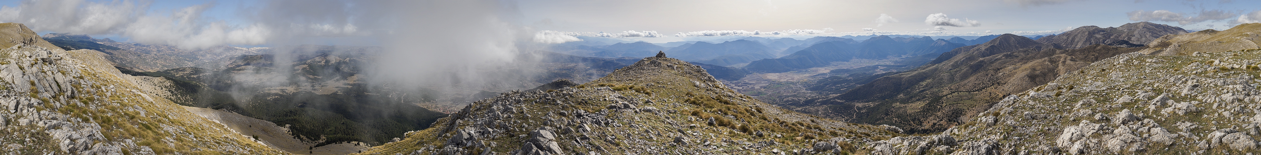
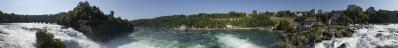
Vorab hatte ich recherchiert, daß man dort auf 850m am Gästehaus der Bergsteigervereinigung EOF parken können müsste und dort ein Weg losgehen sollte. Vor Ort stellten sich die letzten Meter der Straße und der Parkplatz als ruppiger als erwartet heraus - zumindest für mein diesmal sehr kleines Auto. Ebenso unerwartet zeigte aber ein roter Punkt den Beginn des Weges an, und die Markierungen waren dann auch weiterhin so dicht und gut, daß ich meine GPS Tracks kaum bemühen musste. In Griechenland gibt es zudem die Gewohnheit, als Markierung in waldigen Wegabschnitten Streifen von rotweissen Absperrbändern an die Äste zu Knoten - sehr hilfreich. Nach abwechslungsreichem Aufstieg durch verschieden dichte Wälder und an einer Hochebene vorbei endete der so bezeichnete Weg an der Waldgrenze auf ca. 1750m (hier von oben sichtbar). Der restliche Aufstieg war dann steil und weglos, aber letztlich unproblematisch. Durchaus erschöpft, aber glücklich kam ich auf dem östlichsten Gipfel der Kette, dem Dousias, an.
Die Quellwolken waren zwischenzeitlich natürlich auch aktiv geworden und versperrten den am Vorabend genossenen Blick nach Norden auf Giona und Parnass in Mittelgriechenland jenseits des Golfs von Korinth. Dafür war der Blick nach Süden auf Parnon und Taygetos - den Zielen für den weiteren Verlauf der Reise - noch deutlich besser.
=======================================
Continuation of a series covering several years at the Ziria Massiv. During the hike to the highest peak (also Kyllini) in November 2016 I had already noticed the "small" eastern part beyond the Flambouritsa Valley as an attractive mountain destination. Since good weather was forecast, I decided to attempt this destination on the first full day of this year's trip. From my accommodation directly at the sea in Xylokastro, I drove on a beautiful, winding road in three quarters of an hour to the mountain village of Kefalari.
I had researched beforehand that it should be possible to park there at 850m at the guesthouse of the mountaineering association EOF and that a path should start there. On site the last meters of the road and the car park turned out to be rougher than expected. But just as unexpectedly a red dot indicated the beginning of the trail, and the markings were so dense and good that I hardly had to use my GPS tracks. In Greece there is also the habit of using strips of red and white barrier tape on the branches to form knots as markings in wooded sections of the path - very helpful. After a varied ascent through forests of different densities and past a plateau, the marked trail ended at the tree line at about 1750m (visible here from above). The rest of the ascent was then steep and pathless, but ultimately unproblematic. Exhausted but happy I arrived at the easternmost peak of the chain, the Dousias.
In the meantime, the clouds had become active and blocked the view of Giona and Parnassus in Central Greece beyond the Gulf of Corinth, which I had enjoyed the evening before. But the view to the south to Parnon and Taygetos - the destinations for the next days of the trip - was even better.
=======================================
Olympus OM-D E-M5 III
M.Zuiko 12-40/2.8 Pro @17mm (=34mm KB)
21 HF RAW freihand, ISO 200, 1/800, f8
Lightroom Classic CC, Autopano Giga 4.4.2, IrfanView
360° Blickwinkel
Direktlink auf Google Maps: https://goo.gl/maps/zCiyHkUadR5vPHwH7
Recherche für die Beschriftung wie üblich schrittweise im Laufe der Woche
Peter Brandt, Jörg Braukmann, Hans-Jörg Bäuerle, Friedemann Dittrich, Leonhard Huber, Heinz Höra, Dieter Leimkötter, Niels Müller-Warmuth, Jan Lindgaard Rasmussen, Silas S, Björn Sothmann, Konrad Sus, Markus Ulmer, Arjan Veldhuis, Jens Vischer, Augustin Werner
|
 |


Comments
Die Jugend, die Du früher öfter erwähnt hast, ist aber jetzt nicht mehr dabei?
@Heinz - ist ja keine neue Gegend, sondern dieselbe wie November 2016. Die Jugend ist mittlerweile ausgezogen, kommt manchmal noch mit (wie im Herbst 2019 oder wenn der Skipass in Zermatt bezahlt wird :-), manchmal (wie hier) auch nicht. Der normale Lauf des Lebens...
Herzliche Grüße
Hans-Jörg
Leave a comment