|
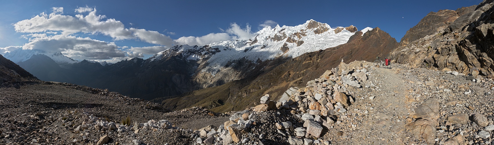
Punta Olimpica is the main crossing of the Cordillera Blanca, with its paved road connecting Huaylas and Conchucos. Several regular buses, run by companies like Renzo or Suiza Peruana, travel the road at least twice a day in either direction. Now the 4890 m top has been bypassed, at 4736 m, by a 1384 m long tunnel. The old road is in the condition that you can argue from the image, although the majors of the regions promised to maintain it for touristic purposes.
I went up to the narrow saddle, coming down the same way, since on the opposite side the adventurous stretch is longer, and seemed also very likely to be interrupted by landslides. I also wanted to cycle the tunnel, although this turned out not to be a pleasant experience, due to several frozen stretches hidden in the total darkness. Then I rode the whole descent to Chacas, at 3300 m, with the help of the moonlight - no vehicle and no evidence of life all around.
According to the GPS, the ascent from Carhuaz, 2600 m, to the 4890 m point, is 51.4 km long, the descent to Chacas is 34.2 km long.
https://bit.ly/3dzbZhE
Hans-Jürgen Bayer, Hans-Jörg Bäuerle, Günter Diez, Johannes Ha, Leonhard Huber, Walter Huber, Heinz Höra, Martin Kraus, Dieter Leimkötter, Wilfried Malz, Giuseppe Marzulli, Steffen Minack, Jan Lindgaard Rasmussen, Arne Rönsch, Björn Sothmann, Michael Strasser, Konrad Sus, Arjan Veldhuis, Jens Vischer, Benjamin Vogel
|
 |


Comments
Bei uns wurde es erst durch Corona populär, ein Fahrrad mit aufs Bild zu nehmen.
Leave a comment