Imja Tse   91104
vorheriges Panorama
nächstes Panorama
Himmelsrichtungen ein / ausHimmelsrichtungen ein / aus
Details / LegendeDetails / Legende Marker ein / ausMarker ein / aus Übersicht ein / ausÜbersicht ein / aus   
 Durchlauf:   zum ersten Punkt zum vorherigen Punkt Durchlauf abbrechen
Durchlauf starten
Durchlauf anhalten
zum nächsten Punkt zum letzten Punkt
  verkleinern
 

Legende

1 Chomo Lonzo, 7790
2 Cho Pholu, 6734
3 Makalu, 8463, 15 km
4 Baruntse, 7152
5 Hunku, 6097
6 Amphu Lapcha, 5845
7 Peak 41, 6623
8 Meka Peak, 6476, 25 km
9 Imja Tso, 5010
10 Malanphulan, 6571
11 6362
12 Kangtega, 6779
13 Thamserku, 6623
14 Ama Dablam, 6812
15 Numbur, 6958, 40 km
16 Taweche, 6542
17 Gaurishankar, 7146, 50 km
18 Menlungtse, 7181, 50 km
19 Nangpa P 6097
20 Cho Oyu, 8201, 33 km

Details

Aufnahmestandort: Island Peak (6189 m)      Fotografiert von: Pedrotti Alberto
Gebiet: Nepal      Datum: 20-04-2019
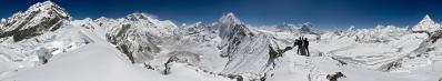
I have one other riddle for the Betrachter.

Here the questions to be answered are the following:
1) where we are. It is such a pity that I forgot the exact spot;
2) why the panorama is not 360°;
3) which is the mountain featuring the nice Hörnligrat to be seen after the second third of the picture.

Beware not to push the Hörnli image too far. Namely, forgetting about mountain ridges and coming to different aspects like, for example, the GNP per capita, a factor of 117 divides the country of the Hörnli and the one here...

Location: 27.920056 86.934656
Larger: https://bit.ly/2S2EFbh
GPS track: http://www.wikiloc.com/wikiloc/view.do?id=61904274

Kommentare

What came first to my mind is a female mountain well known to be alike the Hörnli but wearing a necklace like collar of glaciers. This side is less often photographed, we are north of the mountain. Hence the Grat is showing to the north; another similarity.
23.08.2019 00:47 , Christoph Seger
orientation 
Furtheron: The white area to the right of the clouds - this is a (glacier) lake. The glacier to the right helps you to navigate trough this setting
23.08.2019 00:50 , Christoph Seger
1 & 2 
The point your are taking the picture from is like an icy island; with higher peaks around - especially to the north.
23.08.2019 00:51 , Christoph Seger
Bravo!
Ausrichtung check and labeling when Udeuschle will be lebendig again.
23.08.2019 12:14 , Pedrotti Alberto
Hopefully it will come back soon. Otherwise check out

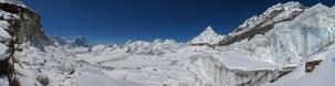
Peakfinder - here from a nearby peak ....

https://www.peakfinder.org/?lat=27.8612&lng=86.8615&azi=293&zoom=5&ele=6814&name=Ama%20Dablam
23.08.2019 15:51 , Christoph Seger
Oder https://www.mountainpanoramas.com/___p/___p.html?panoid=2018_BR
Auch wenn, seit langer Zeit, mein Firefox auf Ubuntu 14 immer neue Probleme mit Adobe Flash hat...
23.08.2019 16:01 , Pedrotti Alberto
Now checked with Udeuschle.
Larger http://bit.ly/2Hsj3zI
25.08.2019 19:09 , Pedrotti Alberto
Great stuff, great view. Sorry - was too busy last week to participate. Would have still started around A.D. after a first glimpse.

@Christoph: You can use peakfinder from any location with the map feature.

Cheers
Martin
26.08.2019 19:52 , Martin Kraus
Martin - I know.
27.08.2019 04:31 , Christoph Seger

Kommentar schreiben


Pedrotti Alberto

Weitere Panoramen

... in der Umgebung  
... aus den Top 100