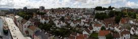
| Cycle through labels: |
|
| Tveitakvittingen 1299 m, 132 km |
| Tysnessåta, Tysnesøya island, 752 m, 97 km |
| Mehammersåta 748 m, 81 km |
| STORD island |
| Stovegolvet 702 m, 78 km |
| Siggjo, Bømlo island, 472 m, 68 km |
| Folgefonna glacier 1600 m, 143 km |
| Gygrastolen 1339 m, 122 km |
| Børøyklampen, Bømlo island, 170 m, 56 km |
| Melderskin 1423 m, 115 km |
| Bjørndalstindane 1426 m, 116 km |
| Englafjellet 1200 m, 98 km |
| Folgefonna glacier 1600 m, 111 km |
| Geidalstind 1185 m, 100 km |
| Høgeteen 1246 m, 100 km |
| Folgefonna glacier 1550 m, 127 km |
| Blådalshorda 1302 m, 114 km |
| Trollevassnibbla 432 m, 69 km |
| Bjørnebærnuten 1305 m, 117 km |
| Alvaldsnuten 1233 m, 113 km |
| Kvangernut 1084 m, 109 km |
| Søndre krossfonnuten 1562 m, 142 km |
| Åsbufjellet 169 m, 58 km |
| Møssegronuten 1136 m, 113 km |
| Hestaskardnuten 1054 m, 110 km |
| Kvannurdenuten 1384 m, 122 km |
| Gråhorga 740 m, 76 km |
| Trollafjellet 637 m, 73 km |
| Kyrkjeknuten 1602 m, 130 km |
| Nordreskornuten 1282 m, 110 km |
| Smalenuten 631 m, 73 km |
| Bordfjellet 1074 m, 101 km |
| Vassnuten, 70 km |
| Aksla, 78 km |
| Døldavarden 735 m, 80 km |
| Fjellhaugen, 54 km |
| Hustveitsåta 1187 m, 103 km |
| Søre Såtene 1187 m, 101 km |
| Kaldanuten 954 m, 97 km |
| Litla Kjort, 77 km |
| Storefjellnibba, 69 km |
| Sellandsnuten 954 m, 98 km |
| Kaldefjell 1449 m, 134 km |
| Snønuten 1602 m, 137 km |
| Strannafjellet 536 m, 71 km |
| Skurvenuten 862 m, 86 km |
| Lammanuten 631 m, 73 km |
| Utsira lighthouse, 23 km |
The last pano from a trip to the Faroes in 2015. When sailing home, strong eastern winds had us going for shelter along the norwegian west coast. As the pano off Shetland (#22040) earlier in the day showed, the weather was quite bad, so I didn't have high expectations for the norwegian approach. As we neared, the fog and clouds dissolved just enough to get a decent view to Norway, if still somewhat hazy. I wasn't that impressed (although I always like looking at Norway :-) until I got home and found out that the farthest views exceeded 100 km. What we see is roughly the lands between Bergen and Stavanger, and the landscapes of Hordaland and Rogaland.
Pano made from 28 pics (RAW), 300 mm, iso-200, f/6,3, 1/800 s, developed in DPP (daylight, neutral, ALO off, moderate sharpness), stitched in PTgui pro, black- and whitepoint regulated in GIMP, downscaled and sharpened in Irfanview. Description and labels in progress, more in the evening... |
||||||||||||||||
|
|||||||


Comments
Hello Friedemann and Mentor: Because of the slightly shaky boat, I was a bit slow at shooting the pictures; there is more than a minute between the first and the last. Immediately afterwards I took a snapshot of the ships infoscreen, which contained position, speed etc. It was going 17,6 knots, so when calculating with 60 seconds, that gives appr. 550 m, that the ship was moving during shooting. When stitching there wasn't any autogenerated control points, so, hard work with manual setting: pictures in 100%, and look for distinct marks in the landscape. 2 control points on every pair is enough, if they are put on right. Even at these distances, the speed made every control point slightly uneven, so at first one gets a snake-like pano. Then my method is to simply cheat the stitcher by moving one of the points very little to either right or left, until it gets straight. Heinz has another method of simply glueing them without controlpoints, as described on among others #3032, 4711, 14002, 15552. I haven't yet tried it out, but will try to look into it.
Gewundert hatte ich mich, woher Du die Position des Schaiffes hattest. Jetzt ist es klar.
Jan, wenn man keine normalen Kontrollpunkte setzen kann, dann habe ich verschiedene Methoden angewendet, auch bei den von Dir genannten Panoramen. Bei #22065 hatte ich für die Bilder zwischen Oie und Usedom wieder gar keine Kontrollpunkte gehabt und sie durch verändern Yaw-, Pitch- und Roll-Werte in eine passende Position gebracht.
Leave a comment