
| Cycle through labels: |
|
| Capu Licchia, 639 m, 22.7 km |
| Capo Tondo, 18.6 km |
| Golfe de Galeria |
| Mont Martino, 19.9 km |
| Sommet de lArgentelle, 18.2 km |
| Pointe de Vigatoggio, 23.6 km |
| Monte Cinto, 824 m, 20.3 km |
| Capo di Vegno, 1388 m, 12.5 km |
| Capo alla Veta, 703 m, 23.6 km |
| Golfe de Calvi |
| Capo al Ceppo, 1951 m, 8.6 km |
| Capo dOcci, 26.8 km |
| Capo al Dente, 2029 m, 14.7 km |
| Monte Grosso, 1938 m, 18.1 km |
| Mont Corona, 2144 m, 13.4 km |
| Cima della Statoja, 2269 m, 14.2 km |
| Monte Padro, 2390 m, 16.5 km |
| Punta Minuta, 2556 m, 4.7 km |
| Monte Cinto, 2706 m, 6.9 km |
| Monte San Petrone, 1767 m, 37.4 km |
| Pointe de Caldane |
| Pointe Galghello, 18.6 km |
| Lac de Calacuccia, 793 m |
| Pointe Caracuto, 37.1 km |
| Pointe Caracuto, 37.1 km |
| Mont Corbajo, 23 km |
| Pointe Lattiniccia, 2413 m, 23.4 km |
| Monte Rotondo, 2625 m, 20.4 km |
| Punta Artica, 2327 m, 11.5 km |
| La Moniccia, 19.8 km |
| Monte d'Oro, 2389 m, 29.1 km |
| Monte Renoso, 2352 m, 37.8 km |
| Mont Niello, 38.5 km |
| Monte Incudine, 2134 m, 61.2 km |
| Mont Retto, 10.2 km |
| Pointe Liciola, 2235 m, 2.6 km |
| Mont San-Pietro, 65.6 km |
| Mont Cervello, 22.5 km |
| Pointe SantElisco, 31.9 km |
| Golfe d`Ajaccio |
| Golo - Tal (Anstiegsweg) |
| Punta dAquilone, 44 km |
| Sommet Scudo, 49.7 km |
| Punta di e Saltelle, 25.3 km |
| Capu â Cuccula, 2049 m, 5.7 km |
| Punta di Marinaccia, 46.9 km |
| Golfe de Sagone |
| Capo Riccio, 23.2 km |
| Capo dello Vitullo, 1331 m, 19.5 km |
| Capo d'Orto, 1294 m, 18.3 km |
| Mont Rao, 26.4 km |
| Capu Tafunatu, 2343 m |
| Golfe de Porto |
| Capo al Cielo, 1586 m, 9.2 km |
| Mont Senino, 619 m, 22.2 km |
| Capu a Ghiallichiccia, 1619 m, 9.9 km |
| Capu Purcile, 560 m, 25 km |
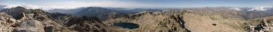
Start der Wanderung ist die Straßenkehre "Le Fer a Cheval", 1329 m, ca. 2 km östlich des Col de Verghio.
Der Weg folgt lange dem Golo, hier noch ein kleiner Bergbach, der sich im weitern Lauf zum längsten Fluss Korsikas entwickelt. Am Refuge Ciottuli di i Mori verläßt man den Bachlauf und steigt steil über Geröll und Felsen auf den Gipfel. Canon Powershot SX 20is 14 QF-Bilder freihand; 10:45 Uhr; 1/400 Sek; F/8,0; ISO 100; Hugin/Gimp/udeuschle.de |
||||||||||||||||
|
|||||||


Comments
Herzliche Grüße
Hans-Jörg
Auch ich denke gerne an solche besonderen Touren zurück.
VG, Manfred
Leave a comment