High, Western and Low Tatras   103242
vorheriges Panorama
nächstes Panorama
Details / LegendeDetails / Legende Marker ein / ausMarker ein / aus Übersicht ein / ausÜbersicht ein / aus   
 Durchlauf:   zum ersten Punkt zum vorherigen Punkt Durchlauf abbrechen
Durchlauf starten
Durchlauf anhalten
zum nächsten Punkt zum letzten Punkt
  verkleinern
 

Legende

1 Dzumbier - 2043 m
2 Velky Bok - 1727 m
3 Krakova Hola - 1751 m
4 Poludnica
5 Velky Choc - 1608 m
6 Holica - 1551 m
7 Baranec - 2185 m
8 Rohacze
9 Jakubina - 2194 m
10 Klin - 2176 m
11 Bystra - 2248 m
12 Kamienista - 2156 m
13 Smrecinski Wierch - 2085 m
14 Czerwone Wierchy - 2122 m
15 Krivan - 2494 m
16 Velke Solisko - 2413 m
17 Strbski Stit - 2381 m
18 Satan - 2421 m
19 Mieguszowieckie Szczyty
20 Vysoka - 2565 m
21 Koncista - 2538 m
22 Gerlach - 2655 m
23 Bradavica - 2476 m
24 Lodowy Szczyt - 2627 m
25 Lomnica - 2634 m
26 Tatry Bielskie
27 Slovensky Raj
28 Kralova Hola - 1946 m

Details

Aufnahmestandort: Kralova Hola (1946 m)      Fotografiert von: Konrad Sus
Gebiet: Slovakia      Datum: 3.10.2015
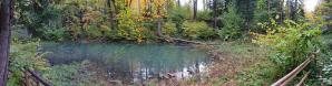
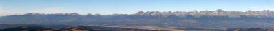
Kralova hola in one of the most prominent mountains in Nizke (LOW) Tatry range. At summit is a huge transmitter. Its the highest place in Western Carpathians, where we can ride by bicycle. To hike we can choose villages, situated at foot of this mountain: Telgart, Sumiac or Vernar. Some parts of slopes are covered by broken trees after heavy halny (fen) wind.

Kommentare

Herrlich, dieser Blick auf West- und Hohe Tatra.
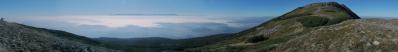
Super-Sicht, obwohl die Hohe Tatra ja nur gut 30km entfernt ist.
05.10.2015 22:44 , Heinz Höra
Do you think that my little Lajstroch (picasaweb.google.com/albertopedrotti/TatraGlockner#5202464648914785698) is visible, or is it in clouds?
Cheers, Alberto.
05.10.2015 23:00 , Pedrotti Alberto
;- )) ...wie Ihr alle diese Standorte findet??!! 
Panorama mit Pfiff!
Gruss Walter
06.10.2015 08:43 , Walter Schmidt
I like it. The radio-mast is leaning a bit, but it doesn't matter in my opinion.
I've been there often in the 80's and it's time to come back again.
Maybe you can tell some technical datas: the focal length for example.
06.10.2015 16:50 , Steffen Minack
Re: Alberto 
I thin Lajstroch is in clouds, its in range toward Dzumbier, as You can see, there is clouds level abou 2000 m.
Greetings
06.10.2015 16:54 , Konrad Sus
Re: Steffen 
Camera: Fuji Film S 8600
1/388s
f/6,5
4mm
ISO-100
1/400s
06.10.2015 16:59 , Konrad Sus
What an amazing landscape with clear air! I am pleased that the horizon looks very exactly.
LG Jörg
07.10.2015 19:36 , Jörg Nitz
Great, wide, clear and constructive perspective. It would be possible to remove the antenna and some sky to make other details larger.
09.10.2015 14:57 , Jörg Braukmann
Thank you Konrad for researching.
I thought that it could be the little hill right of the clouds.
But perhaps the Sadlo Certovica already lies hidden below them.
Cheers, Alberto.
10.10.2015 21:09 , Pedrotti Alberto
Re: 
I tried to find mounts right to Dumbier and 99% Lajstroch isn`t visible.
Greetings
14.10.2015 19:59 , Konrad Sus

Kommentar schreiben


Konrad Sus

Portfolio

Weitere Panoramen

... in der Umgebung  
... aus den Top 100