|
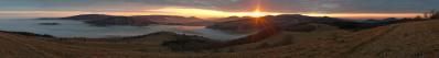
Der eigentliche Grenzübertritt von Bolivien nach Chile erfolgt an einem kleinen Grenzübergang, der sich weit oben auf dem Portezuelo del Cajón-Pass auf 4.480 m Höhe befindet. Die übrigen Einreiseformalitäten sowie die zugehörige Gepäckkontrolle werden jedoch erst weiter unten in San Pedro de Atacama durchgeführt. Hier werden neben den einreisenden Touristen auch dutzende LKWs, die das nahe Dreiländereck Argentinien-Bolivien-Chile passieren, abgefertigt.
Ich hatte an diesem herrlichen Abend Glück, dass mich die obligatorische Stichprobe mit der ausgiebigen Gepäckuntersuchung nicht traf und ich stattdessen - während einige der Mitreisenden selbige noch über sich ergehen lassen mussten - genug Zeit für dieses Panorama zur Verfügung hatte. Dazu musste ich nur ein paar Schritte aus dem Zollgebäude und zwischen den wartenden LKWs hindurch machen und schon bot sich dieser traumhafte Anblick.
Die Farben der Berge änderten sich an diesem Abend minütlich mit der immer tiefer stehenden Sonne, ein Spektakel, welches wir glücklicherweise am Folgetag nochmals in vollem Maße genießen durften.
11 QF Aufnahmen á 105mm, F7.1, 1/400s, ISO200
Pedrotti Alberto, Sebastian Becher, Peter Brandt, Jörg Braukmann, Arno Bruckardt, Hans-Jörg Bäuerle, Friedemann Dittrich, Gerhard Eidenberger, Jörg Engelhardt, Leonhard Huber, Martin Kraus, Wilfried Malz, Jörg Nitz, Jan Lindgaard Rasmussen, Danko Rihter, Matthias Stoffels
|
 |


Comments
I wonder whether what is seen at 90° is really the Ruta 27 to Paso Jama. If this were the case, I would understand very well the definition given me by a Chilean truck driver (now retired): "un infierno de tierra", so he defined, when asked, both Paso de Jama and Paso de Sico.
But I thank you especially for showing such a clear view of the Sairecabur, which should be one of the highest spots in the world that can be not only reached, but even traversed (!!) by bicycle: check pikesonbikes.com/traversing-sairecabur Please do no spread too much this information, since as for now it seems to be known truly to a restricted audience, and it would be nice if things could remain such.
I remember few years ago the traverse from the south end of the Carretera Austral to El Chaltén, via boat on Lago O'Higgins, then pushing the bicycle up the track of the Portezuelo de la Divisoria, then again by boat on the Lago del Desierto, being known only to "authentic pioneers"... now those boats carry maybe 30 bicycles a day!
Another question about volcanoes. Do you know whether among the summits that one guesses left of Sairecabur there is also, maybe half-hidden, the Volcán Putana? If you know the meaning of this term in Italian (and in Spanish it is not much different) you will realize the reason of my funny curiosity...
A very last observation to end my cumbersome and boring comment. I am literally amazed to be the first among nearly 50 people to react to a work of such beauty and information content. Be understood that I do not like much the scientific Bewertungology which I see periodically resurrecting here - especially when it even reveals a zealous, yet unrequested, effort of monitoring and judging other people's habits.
However, faced with a case like the present one, I feel a fear growing... The fear is whether also these platforms are going to follow the behaviour of many other ones, where an object (be it an image or a climbing/ski/cycling report, or anything else) is appreciated only if the sensation awakened is of the type "Well, this is beautiful a beautiful work AND/BUT I have the chance to go and to do the same by myself tomorrow".
Cheers, Alberto.
The road that can be seen at 90° is indeed the Ruta 27. However, I can not confirm completely the words given by the Chilean truck driver. The section of the Ruta 27 following the intersection with the B243 coming down from Laguna Verde has been modernized with good asphalt recently. For me it looked like a nice downhill road for a bycicle, and for the truckers there are lots bracking lanes on the side (in case the brakes give up to work...).
Regarding Sairecábur: Thanks for the great link! I promise I will not spread it widely. By the way, the mountain right of Liancabur, Cerro Toco (pano 16497), can almost be reached by car, since there is a space observatory on it.
When I searched for mountain labels I crossed peakfinder.org, there the Sairecábur is labelled as Cerro Volcán Putana, which I think is wrong. Where the real Putana is located I cannot tell you, an information like this is usually not spread over the open internet ;-)
In www.panoramio.com/photo/3905544 (which I found by the way) you see Putana left and also, very well, the little valley hosting the N track to Sairecabur.
On my GPS I recorded Putana at 5890 m, -22.558, -67.8531. I strongly believe it to be the vaguely white summit at little less than 42° in your image. If I click on it, Udeuschle sends me very close to my coordinate. (Maybe censorship eliminated the name??)
In www.panoramio.com/photo/3905544 (which I found by the way) you see Putana left and also, very well, the little valley hosting the N track to Sairecabur.
Such a label will enormously boost popularity!!
Herzliche Grüße
Hans-Jörg
Herzliche Grüße, Matthias.
Leave a comment