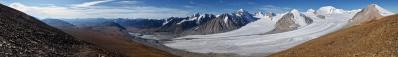
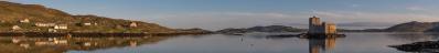
|
This aims to be an instructive photograph, since it depics what I believe to be one of the most unknown corners of Italy, and one of the most neglected, especially in relation to its beauty.
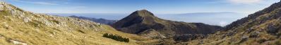
Here we see the Calabrian side of the Pollino, with the Raganello gorge enclosed between two typical rock formations called Timpe: Timpa di Porace and Timpa di San Lorenzo - the later named after the remote village of San Lorenzo Bellizzi (www.panoramio.com/photo/76869794).
On the other side of the valley we see the track ascending from Civita, one of the Albanian villages of Northern Calabria, to the mountain.
Here I am standing on the top of Monte Séllaro, and unknown belvedere which I discovered by map inspection. It dominates the likewise panoramic village of Cerchiara di Calabria and, higher up, the Santuario Madonna delle Armi (www.panoramio.com/photo/91955505).
The Betracher asks how I came across this old picture. The ispiration came from a discovery that I made a couple of days ago about Morano which is a village very similar to Cerchiara, lying short outside the left margin of the panorama. Just type: Morano Escher.
|
 |


Comments
But the worst thing is that I was even here.
In 2006, when I undertook CiclAlpItalia (the project to climb in sequence the highest mountain of each of the 20 Italian regions, picasaweb.google.com/albertopedrotti/CiclAlpItalia) it was doubtless the most striking discovery.
Saluti,
Alberto.
There is one thing that connects the Pollino with the Balkans and this is the "pino loricato" (Pinus heldreichii or Bosnian pine). A magnificent tree.
Leave a comment