|
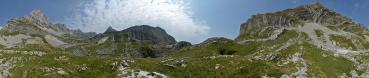
The Durmitor is perhaps the most beloved mountain group in Montenegro, and a very wide range of sports is practised on it. Trekking is of course the number one, with a choice of very well marked paths. The locals claim that their Durmitor is one of the best massifs in the whole Europe under this respect - and they are more than right. Since Durmitor is delimited by the Piva and Tara canyons, rafting (especially on the latter) is also very popular. Most of the agencies organizing tours (mainly of several days, due to the length of these canyons) are based in abljak, the only village of the region which can in some way be called a "town". Off-road cyclists find a challenging 90 km loop around the heart of the massif, but also a variety of tracks, marked as well as the trekking paths. On the same paths and/or tracks, or around the several lakes (the main of which being the Crno Jezero, the Black Lake, only 2 km from abljak) you see also people riding horses. If you like base jumping or traversing valleys attached to a cable, you need only to move down few kms to the impressive bridge of Durdevica, www.panoramio.com/photo/96125589 , reaching a height of 172 metres over the water of the Tara.
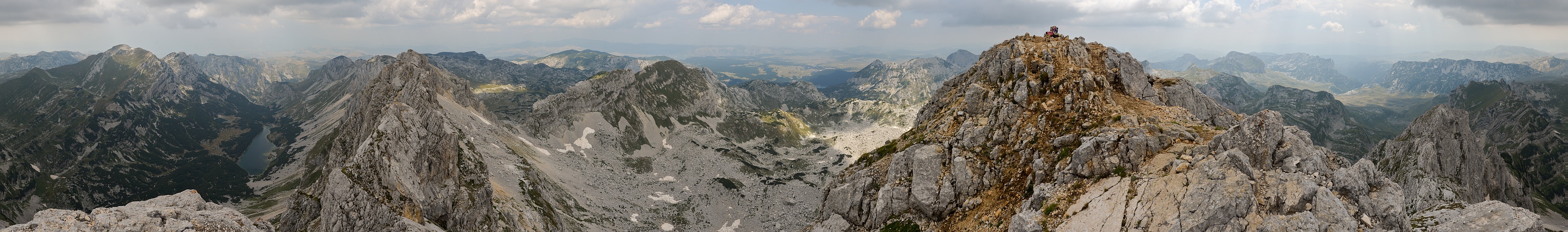
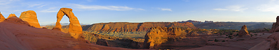
My Durmitor adventure seemed to be finished already before beginning. I had come up the hard way from Pluine (see N.13733), sleeping on the wide high-plains of the mountain, under full moon, www.panoramio.com/photo/95977343 . But the awakening proposed rain, and I was tempted to follow two Austrian motorcyclers who knew very well the place and were abandoning the mountain. Luckily, when riding a bicycle you think two or three times before abandoning what you have conquered so hardly, and I was promptly rewarded by an encouraging improvement of the weather conditions. I parked the bicycle and headed to the main summit, a powerful limestone cliff which dominates by at least 100 m every other elevation in the surroundings. The way to the summit is fairly easy, the climbing passages should be rated no more than I, maybe II- if one wants to exaggerate. The sight that I enjoyed from up there was far from memorable, due to the amount of haze, but - I hope - instructive nevertheless.
For the panoramic operations I stood a little away from the summit, in order to gain the sight also on what is perhaps the hidden treasure of the massif, namely, the krčko Jezero which looks out as beautiful as the pronunciation of this name sounds awkward!
People in Montenegro often consider the Bobotov Kuk to be their highest summit, at 2523 m. This is not true since in the Prokletije no less than three summits beat it, although only for a handful of metres: Zla Kolata / Kolata e Keq, 2534; Dobra Kolata / Kolata e Mirë, 2524; Maja Rosit, 2524. But all these summits are shared with Albania, as the double names show. The Durmitor instead - as well as the Lovćen, which I will show sooner or later - lies in the heart of Montenegro, as well as in the heart of every Montenegrian!
I6 vertical images, 22 mm (x 1.5), 1/200 sec, f/11.
Larger: www.panoramio.com/photo/95800130
Hans-Jürgen Bayer, Peter Brandt, Klaus Brückner, Hans-Jörg Bäuerle, Hans Diter, Friedemann Dittrich, Jörg Engelhardt, Thomas Janeck, Günther Kleis, Wilfried Malz, Giuseppe Marzulli, Jan Lindgaard Rasmussen, Danko Rihter, Konrad Sus, Jens Vischer
|
 |


Kommentare
lG,
Jörg E.
@Peter B.
Der Sylvensteinstausee kam JE bei Albertos Panorama #13733 in den Sinn, worauf sich ein netter "Gedankenaustausch" entwickelte ;-)
Kommentar schreiben