Central Sjælland in winter (300 mm)   53288
vorheriges Panorama
nächstes Panorama
Himmelsrichtungen ein / ausHimmelsrichtungen ein / aus
Details / LegendeDetails / Legende Marker ein / ausMarker ein / aus Übersicht ein / ausÜbersicht ein / aus   
 Durchlauf:   zum ersten Punkt zum vorherigen Punkt Durchlauf abbrechen
Durchlauf starten
Durchlauf anhalten
zum nächsten Punkt zum letzten Punkt
  verkleinern
 

Legende

1 Dyssebjerg 74 m, 8,7 km
2 Kvanløse Havremark 94 m, 22 km
3 Åmosen low moor 24 m, 5 km
4 Mørkemose Bjerg 105 m, 22 km
5 P. 85 m, 23 km
6 Jukkerup Vænge 84 m, 19 km
7 Lundsbakke 93 m, 21 km
8 P. 102 m, 22 km
9 P. 86 m, 18 km
10 P. 85 m, 18 km
11 Bredbjerg 76 m, 19 km
12 Åmosen low moor 24 m, 12 km
13 Grøftebakke 75 m, 21 km
14 Åmosen 24 m, 13 km
15 Egstallebjerg 94 m, 33 km
16 Røgerup Skov 71 m, 36 km
17 Ugerløse Kirke (church), 19 km
18 P. 104 m, 32 km
19 Lerbjerg tele tower 67 m + 103 mNN = 170 m, 32 km
20 Skovbakke 113 m, 32 km
21 Æblebjerg 111 m, 32 km
22 Høbjerg 117 m, 32 km
23 Højbjerg 118 m, 31 km
24 Gyldenløveshøj 126 m, 32 km
25 Rødehus 83 m, 30 km
26 Old dairy plant, 8 km
27 Klejnsmedskov 82 m, 30 km
28 Niløse Kirke (church), 9 km
29 Ordrup Bakke 82 m, 24 km
30 Højbjerge 81 m, 22 km
31 Brick yard, 11 km

Details

Aufnahmestandort: Kløveshøj (100 m)      Fotografiert von: Jan Lindgaard Rasmussen
Gebiet: Denmark      Datum: 2013-01-20, 16:18
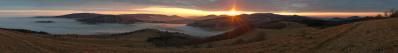
After the overview I shot some series with the 300 mm. The view goes to some of the highest parts of central Sjælland, above the 100 m...don't get dizzy:-)

The landscape were created by, from a danish translation, so-called dead ice. Enormous blocks of ice broke off the retreating glaciers, and since it was no longer moving it is called dead ice. All the stones, clay and gravel in and on the ice was slowly assembling in depressions on the ice-shield, more and more as these glacial lakes melted deeper and deeper. Therefore the hills are simply sediment from these lakes.

The hill Gyldenløves Høj is generelly thought of as the highest point on Sjælland, with 126 m. However, most danish hills have a tumulus on top, and the highest natural hill on Sjælland is a disputed matter. What is nature and what is culture? In the case of Gyldenløves Høj the matter is obviously a "fake". In the 16-17hundreds, Gyldenløve (golden-lion) was a noblemans name given to the bastardsons of a series of kings in Denmark back then. One of them wanted to make sure, that his hill was the highest on Sjælland, and so he had enormous amounts of soil filled on top of his hill.

Pano made from 17 pics (RAW), developed in DPP (moderate sharpness, 7000 K, Neutral), 300 mm handheld, iso-400, f/6,3, 1/500 sec. Stitched with PTgui pro, re-scaled and sharpened in IrfanView.

Kommentare

Another lesson in Danish geography. LG Wilfried
21.03.2013 11:36 , Wilfried Malz
And a special light.
21.03.2013 15:08 , Jörg Braukmann
This kind of panos has become a classic for you.
21.03.2013 21:41 , Giuseppe Marzulli
Schöne (fast) Monochromie!
Cheers, Danko.
23.03.2013 00:09 , Danko Rihter
Reload 
Following the hints about redshift and other stuff (13889), I have de-saturated, taken out magenta and blue/added green and yellow. See the old pano on test site #10164.
22.10.2013 19:37 , Jan Lindgaard Rasmussen

Kommentar schreiben


Jan Lindgaard Rasmussen

Portfolio

Weitere Panoramen

... in der Umgebung  
... aus den Top 100