|
There are two major roads which cross the Moroccan Atlas: the one of Tizi-n-Tichka and the one of Tizi-n-Test. But there is also a third, far more adventurous road, which joins Demnate on the Atlantic side to Ouarzazate on the Sahara side, crossing three successive passes well above 2000 metres: Tizi-n-Outfi, Tizi-n-Fedhrat and a third Tizi whose name I had not yed been able to locate on any source.
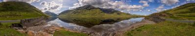
I was cycling under discontinuous rain, accompanied on the left side by a "moving" rainbow, when I reached the Atlas main watershed at Tizi-n-Fedhrat. Here, looking in the direction of the desert, I came to see again blue sky. But on the right side there was a high mountain which seemed not to want to come out of its clouds. Since I did not know its name (on the Michelin map it is appears as an anonymous point 3607), I christened it "the stormy mountain".
That day - it was December 25 - I did neither know nor suspect that I was going to climb that mountain from the other side, few days later, namely, on January 06. and I was also going to finally get to know its name: Inghamar, or Anghomar, or Anghoumar. Now on the Marco Polo map I even read Anrhomer.
I have been impressed so much by this unknown mountain, and by the beauty of the surrounding environment, that I have dedicated to it a summit log on Peakware, see http://www.peakware.com/peaks.html?pk=2483
It is also worth to note that the Inghamar is the highest summit between the Toubkal and Mgoun massifs which, as everybody knows, are the two Moroccan 4000s.
|
 |


Comments
Leave a comment