
| Cycle through labels: |
|
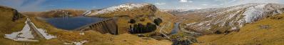
| Corndon Hill (513m) |
| Long Mynd(516m) |
| Wenlock Edge |
| Titterstone Clee (533m) |
| Brown Clee Hill (540m) |
| The Wrekin (407m) |
| Worcestershie Beacon (435m) |
| Great Malvern |
| Dudley |
| Clent Hills (315m) |
| Worcester |
| Lickey Hills (298m) |
| Stratford on Avon |
| Edge Hill - Cotswolds (219m) |
| Broadway |
| Bredon Hill (299m) |
| Upton on Severn |
| Cotswolds |
| Cheltenham |
| Gloucester |
| River Severn Estuary |
| May Hill (296m) |
| British Camp (338m) |
| Forest of Dean |
| Monmouth |
| Sugar Loaf (598m) Abergavenny |
| The Black Mountains (719m) |
| Hay Bluff (677m) |
| Hereford |
| The Wye Valley |
| Radnor Forest (660m) |
Taken from the ridge of the Malvern Hills. From here you can see 9 counties of England and Wales. Mainly overlooking the River Severn and River Wye Valleys.
Canon 7D with 17-55mm lens. 100 ISO 1/160 at f9.0 |
||||||||||||||||
|
|||||||


Comments
Some observers have pointed out that the horizon on your follow up contribution (River Mawddach Estuary) wasn't level.
When looking at the clouds, I would conclude that the horizon in this panorama is probably not perfectly level or straight, either. The beautiful hilly landscape doesn't reveal it, however.
If you can straighten it a bit more, great. But it is good as it is!
Cheers & welcome to Panorama-Photo! Augustin
Best Regards,
Leave a comment