|
This pano is not in the beauty-contest on this site, it is a documentation of a far view in Denmark. In this pano the farthest views exeed 60 km, which is quite long in Denmark, but of course isn't so much compared to the many panos from various Mittelgebirge and higher ranges. Considering the height at 55 m üNN, it is still OK. The reason for these relative long views is, that they stretch over the sea, therefor allowing the full potential of the far horizon. For all my panos, in particular this one, goes that I would love to re-shoot them under better light conditions and in different seasons, but until then this is what I have.
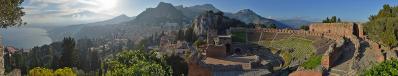
First part of the pano shows some larger structures from the city of Kalundborg. Then we follow Kalundborg Fjord, and the Asnæs peninsula behind it. Both Røsnæs and Asnæs are end-moraines from the Storebælt-glacier (#9421). Down in Storebælt we see the suspended part of the Storebælt-bridge, before moving to Fyn. The most clear part of Fyn is the northeastern peninsula Hindsholm and Romsø island. After Fyn a few far away Jutland hills can just barely be seen, before the group of pines splits Samsø in two. After Samsø a number of small islands and some prominent features on the peninsula of Djursland (the "nose" on Jutland) can be seen.
The view presented here could of course fall a little boring, so I will also present two parts from it, shot with a 300 mm lens, showing the Fyn-part and the Samsø-Djursland-part. Coming soon, I hope!
The location is the highest on the outermost part of Røsnæs (see and read also #8340), but sadly the view over the peninsula is desecrated by a little group of Pines (Pinus nigra). The area is a conservation area, so it is unbelievable why they get to destroy the view since they are introduced as a species (nicht heimisch!), and the protected biotope here is dry pasture (Weide).
The name Vågehøj means Hill from where to watch (Wachen-Hügel). As you can imagine the strategic value is huge, since the traffic from Storebælt can be monitored from here. During the german occupation 1940-45 a bunker was build in the hill, and afterwards it was used during the cold war. It is now deserted, and can be visited at any time.
The pano has taken a long time to make. Especially the low standing sun was a challenge, to put it mildly. I ended up (in RAW-treatment) trying to make the central picture a little underexposed, and taking out the highlights from it. Then, on each side of it going outwards, I gradually lightened the pics, and after 4 pics on each side they have equal treatment. Then they were stitched in Hugin, using the "blend from stacks"-function.
31 pics handheld, 80 mm (28-80 mm kit-lens from my old analog EOS-50), f/13, 1/200 sec, iso-200. A little GIMP to remove spots, scaled and sharpened in IrfanView.
Hans-Jürgen Bayer, Jörg Braukmann, Hans-Jörg Bäuerle, Gerhard Eidenberger, Velten Feurich, Heinz Höra, Johann Ilmberger, Franz Kerscher, Martin Kraus, Geir Anders Langangen, Wilfried Malz, Stephan Messner, Jörg Nitz, Danko Rihter, Werner Schelberger, Christoph Seger, Robert Viehl, Jens Vischer
|
 |


Comments
Great scenery and of course all ligned up very well ! Difficult light situation especially in the far distance but still authentic. To the left a bit dark but still good on my monitor - low noise, impressive. Greetings HJ
Cheers, Danko.
Cheers, Martin
PS: I have noticed you have been silently appreciating some of the older material on this site and on a-p. Thanks for that - I sometimes find it a bit dis-illusioning that most panoramas receive attention for just a few days, while there is such a wealth of great pictures here now.
LG Jörg
Jan, the far mountains are to be seen very clear in your pano. The Storebelt bridge is most impressing.
The horizon in your pano is good. If one looks exactly, there are again differences in the height between the parts.
The foreground is however somewhat too darkly advised. One can brighten these up nevertheless. If I make, then one can see also the cows very beautiful.
@Martin: It has been quite easy, but very time consuming. I have watched a-p for some years now, so I know the high-rollers ;-). The best way to re-visit old stuff is to browse their portfolios.
@Heinz: Interesting Bornholm-thoughts. It must be possible as a mirroring refraction. Try an early sommer-morning in a high-pressure (high-pressure over the baltic states or northwards) period. Regarding Wollin, low-land far views are different from mountains. A good time to try could be after a front-passage from west, with the wind going in northwest-northeast. Usually it can be very clear (and windy) after low-pressures. Northern wind dries up over scandinavia, and no dust at all are picked up. Only thing can be, that aerosols from the sea are stirred up.
LG Jan.
Leave a comment