|
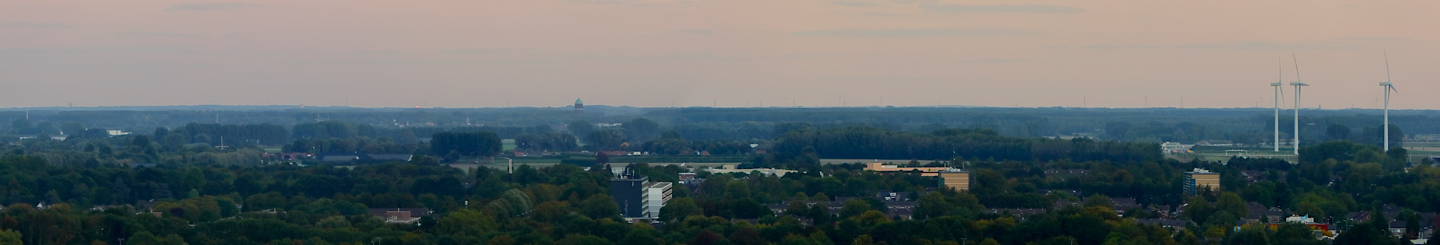
Some time ago, I discovered the northern hills of the Flemish Ardennes (hilly region south of Ghent), at a distance of 45-48 km, are clearly visible from Waterfront (pano 23565). Additional work revealed that even the highest hill: Pottelberg, 157 m (TAW) on the border between Flanders and Wallonia (between La Houppe and Flobecq) sometimes is visible. This hill is at a distance of 64-64.5 km. I never discussed this but I will show on a next pano. So I thought, if this hill is visible, maybe some towers in Brussels, at 62 km to 67 km, are visible too. I didnt find any data suggesting this was seen before, nor by the residents on the higher floors of Waterfront, equipped with 50x scopes.
Now the problem is that the northeastern half of Brussels, with many of the higher towers, is behind the relatively nearby Waasmunster cuesta, visible at left on this pano (left of 147°). This cuesta, only 28-29 km from here, has an elevation of 32 m TAW but is mostly covered with 10 m-20 m high trees resulting in a height of about 40 m to 50 m. So heights (terrain+building) of at least 190-200 m at 65 km, are required to stick out above the trees and they are not there.
However something of the southwestern half should be visible because that part of the city is located just right of the steep edge of the cuesta where terrain+tree heights drop to about 5+20=25 m TAW. In particular, the highest building in Belgium: Tour du Midi or Zuidertoren, 148 m (without antenna), at 65.8 km, should be visible, even taking into account that it is located in the lower parts (20-25 m TAW) of the city, giving a total height between 168-173 m TAW.
So I took a lot of photos on clear, low turbulence days in that direction but mostly found nothing or sporadically something very blurred and difficult to identify. In addition the position on my photographs differed a quarter degree with the Zuidertoren on Google maps. So I wasnt sure. But I found additional clues because I could recognize something that looked like the top of the green dome of the Koekelberg Basilica, which is one of the biggest churches in the world. I could recognize the upper part of the main dome and the smaller dome on top of it. That church in the Brussels suburb Ganshoren, at 62.3 km, is 100 m high but on a 55 m 60 m hill, giving a total height of 155 m to 160 m TAW. I found the angle with the possible (blurred) Zuidertoren on my photograph exactly matched with Google Maps, although the position once again was a quarter degree wrong compared to nearby objects. This top is only very faintly visible on this pano but one will have a better look on my coming discovery pano.
But it are the photographs of this panorama, recorded on September 7, 2018 that allowed me to identify the Zuidertoren with absolute certainty. I was able to capture the reflection of direct orange sunlight on the northwestern glass wall, which horizontally, only happens minutes before sunset. This means one has to be in the right direction at the right time. This condition happens during two short periods per year. Given my position in relation to the Zuidertoren, April 13-15 and August 28-29 are optimal. But I didn't know a few weeks ago. So it was a bit of a coincidence I caught the reflection on Sept 7 which was still quite intense because I could even see it with naked eyes.
So by determining the angle of reflection and comparing the apparent angle of the reflective surface (the northwestern wall) I obtained an absolute proof.
Conclusion: the Zuidertoren, Tour du Midi, the highest tower in Brussels (and in Belgium), at 65.8 km, is the farthest object seen from Waterfront so far. I dont expect to find something at a greater distance until two 200 m+ towers in Rotterdam are finished.
Right of the green Water tower of Axel, a few 70 m hills in Flemish Brabant are visible too such as Kravaalbos/Terrenberg and Kartelobos at distances of about 50 to 52 km.
My sorry for deleting the riddle, which I think would remain unsolved. Jörg Nitz suggested correctly a building in Brussels.
But I copied the comments.
Canon Eos M6 with EF-M 18-150 mm, 3 p RAW, 150 mm (240 mm KB), iso 100, f 8, 1/50 s, PTGuiPro, 10580x3665 156.3 MB TIFF, crop h=1815, downsized>1000>500 TIFF>sharpening>2930x500 977KB JPEG
Hans-Jörg Bäuerle, Friedemann Dittrich, Walter Huber, Heinz Höra, Giuseppe Marzulli, Steffen Minack, Jörg Nitz, Jan Lindgaard Rasmussen, Danko Rihter, Werner Schelberger, Walter Schmidt, Björn Sothmann, Jens Vischer
|
 |


Comments
But, seriously, I really appreciate your attempts.
But the influence of the curvature of the earth should still be considered and the refraction must be estimated.
https://upload.wikimedia.org/wikipedia/commons/6/60/Panoramic_view_of_brussels.jpg
I am also often looking for far distant views from low location.
But I have calculated the elevation angle for Zuidertoren and the Koekelberg Basilica. These are respectively - 0.16 ° in normal refraction. BUT the elevation of Waasmunster cuestas with 32 m TAW + 20 m tall trees at 29 km distance is only - 0.14 °. However, this mean that the range of hills with such tall trees covered the two buildings!
If I do the refraction coefficient greater than 25% (normal value is 13.5%) the elevation angles of the buildings and of the wooded hill are approximately equal size (about -0.13°).
These are only approximate calculations, but they show that exceptionally good visibility conditions must prevail, so that you can see the two buildings in Brussels from your waterfront building.
Concerning my calculation, I increased the zero level of the globe to +25 m to compensate for the horizon and then calculated the theoretical max distance. If this equals the real distance - which it does - the height seen should be 25 m.
Leave a comment