
| Cycle through labels: |
|
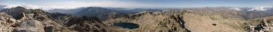
| Pointe de Campana, 1093 m, 32 km |
| Mont Torricella, 23.7 km |
| Punta alla Paglia, 10.2 km |
| Pointe Cali, 12.4 km |
| Pointe Muro, 8.3 km |
| Pointe de Lagoniello, 14.7 km |
| Pointe Carpiniccia, 15 km |
| Rèservoir d`Alzitone |
| Etang d`Urbino |
| Punta della Serra, 17.3 km |
| Pointe Kyrie Eleison, 13.6 km |
| Pointe de Giccia, 15.4 km |
| Punta Bocca di lOru, 15.9 km |
| Punta della Capella, 18.5 km |
| Mont Formicola, 23.6 km |
| Monte Renoso, 2352 m, 9 km |
| Monte Incudine, 2134 m, 33.2 km |
| Mont Niello, 10.9 km |
| Pointe de Sistaja, 30.9 km |
| Montagne de Cagna, 61.4 km |
| Punta del Cavalelli, 37.5 km |
| Mont San-Pietro, 43 km |
| Punta di Mantellucciu, 1679 m, 22.1 km |
| Pointe de Buturetto, 48.4 km |
| Golfe de Valinco |
| Pointe Grimaldella, 31.4 km |
| Punta Cozzanicciu, 36 km |
| Pointe d'Isa, 1630 m, 12.3 km |
| Mont Aragnasco, 27.7 km |
| Golfe d`Ajaccio |
| Sommet Scudo, 42.2 km |
| Pointe de Pozzo di Borgo, 38.9 km |
| Pointe SantElisco, 20.4 km |
| Pointe Migliarello, 2254 m, 2.5 km |
| Punta della Vida, 24.2 km |
| Golfe de Sagone |
| Punta di e Saltelle, 28.1 km |
| Mont Cervello, 16.7 km |
| Capo alla Cuma, 31.9 km |
| Capo dello Vitullo, 1331 m, 34.3 km |
| Capo d'Orto, 1294 m, 34.8 km |
| Mont Retto, 19.8 km |
| Capu â Cuccula, 2049 m, 27.1 km |
| Capo alli Sorbi, 11.9 km |
| Paglia Orba, 2525 m, 29.2 km |
| Punta Artica, 2327 m, 17.8 km |
| La Moniccia, 9.4 km |
| Punta Minuta, 2556 m, 30.7 km |
| Monte Rotondo, 2625 m, 9.4 km |
| Pointe Lattiniccia, 2413 m, 10.6 km |
| Cima delle Folicce, 1310 m, 80.3 km |
| Mont Capra, 72.6 km |
| Monte Stello, 1307 m, 77.1 km |
| Monte San Petrone, 34.4 km |
| Mont Calleruccio, 31.2 km |
| Pointe de Caldane, 29.4 km |
Eine schöne Wanderung, die man als Rundtour gehen kann.
Ausgangspunkt war der Parkplatz am Bahnhof von Vizzavona. Von da aus ging ich Richtung Speloncello-Bach und weiter zur Bergerie de Pozzatelli. Im weitern Verlauf war es nicht immer einfach, den Weg zu finden. Zurück wanderte ich über die Bocca di Porco und entlang der sehenswerten Cascades des Anglais, wo der Agnone-Bach mit vielen Wasserfällen und Gumpen ins Tal rauscht. Canon Powershot SX 20is 19 QF-Bilder freihand; 9:45 Uhr; 1/640 Sek; F/7,1; ISO 80; Hugin/Gimp/udeuschle.de |
||||||||||||||||
|
|||||||


Comments
Leave a comment