|
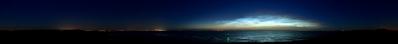
The town of Terneuzen is located along the Scheldt Estuary about 25 km upstream from the North Sea. The North Sea can be distinguished on the horizon at left. Almost all ships going to Antwerp Seaport must pass through here and they come extremely close as they follow the big meander (Bocht van Terneuzen). To the right, this meander turns over into another big meander, the so-called Bocht van Bath. Already more than 40 years ago, Antwerp harbour insisted to cut off the Bocht van Bath with a big canal. However as a significant chunk of the land of Saeftinghe, an extremely precious natural reserve, would be lost, this plan never came through.
The Seaports of Gent and Terneuzen are linked to the Scheldt Estuary with the Gent-Terneuzen sea canal. Several sea locks were built West of Terneuzen and an even bigger lock should be ready in 2021.
Canon G1Xmark2, 9 pics, 21.98mm (41mmKB), iso 250, f7.1, 1/1000, M, JPEG superfine, 190°, stitched with Hugin. Note: to increase the quality I took a crop of about 50 % of the height, seems to be the trick to reduce the crenelated appearance of diagonals.
|
 |


Comments
Leave a comment