|
After that I scattered some Fernsicht-material across the Testplätze, below N.17653 Martin Kraus proposed "to promote the Fernsichten to a real Platz".
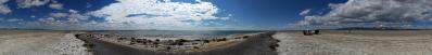
So, here you find the real Platz. Let me explain the three objects juxtaposed:
1) an excerpt from an Einzelbild showing the Peloponnese - object that I found on the disk only thanks to a question posed by Christoph Seger in a commentary to the same pano. The view is opened left by Cape Matapan, the ancient Tenaros once considered the door of the hell, the place where Orpheus descended in search for Euridice. [I guess that, if you do not recognize Orpheus in the picture, this is only because my lenses do not have enough resolution. I will work on this!]. Then, behind the big island of Kythera, you see the surge of Mount Taygetos, the backbone of the whole Mani peninsula, whose culmination, Profitis Ilias, is located at 239 km distance. At the same distance lies Mount Parnonas, which you spot at the right end of the frame, behind the wonderful Cape Maleas, the easternmost of the three "fingers" of Peloponnese. Monemvassia would lie hidden right of this cape;
2) an excerpt of N.17590, another unexpected discovery that I recently made on the disk. The excerpt is focused on the Cyclades, and was shot at evening, when the visibility was optimal in direction Antimilos - Milos, which vaguely resemble Alicudi and Filicudi respectively. Moving right, visibility fades out and I have labelled the islands only up to a certain point;
3) an excerpt of N.17653, showing the Cyclades view at morning. Here the visibilty stretches eastwards to Santorini and even to Anafi, at 197 km. Of my three favourite Cyclades islands, namely Paros, Naxos and Ios, only the latter is to be seen clearly, while the other two appear only as indistinct shadows at 220 and 234 km.
To enhance visibility, I boosted contrast and applied clarity/structure. A light action on the whole of 1, and a stronger action selectively aimed at the background of 2 and 3. Halo avoidance, noise reduction and other very fancy points seemed me totally orthogonal to the scope of a work of this kind.
I have applied basic Himmelsrichtungen by hand to the first picture; for the other two you can refer, more reliably, to the quoted "master" panoramas.
Peloponnese view:
http://www.udeuschle.selfhost.pro/panoramas/panqueryfull.aspx?mode=newstandard&data=lon%3A24.03286%24%24%24lat%3A35.29167%24%24%24alt%3Aauto%24%24%24altcam%3A10%24%24%24hialt%3Atrue%24%24%24resolution%3A200%24%24%24azimut%3A323%24%24%24sweep%3A26%24%24%24leftbound%3A310%24%24%24rightbound%3A336%24%24%24split%3A6%24%24%24splitnr%3A5%24%24%24tilt%3Aauto%24%24%24tiltsplit%3Afalse%24%24%24elexagg%3A1.2%24%24%24range%3A300_grid%24%24%24colorcoding%3Afalse%24%24%24colorcodinglimit%3A80%24%24%24title%3APachnesToPeloponnese%24%24%24description%3A
Cyclades view;
http://www.udeuschle.selfhost.pro/panoramas/panqueryfull.aspx?mode=newstandard&data=lon%3A24.03092%24%24%24lat%3A35.29203%24%24%24alt%3Aauto%24%24%24altcam%3A10%24%24%24hialt%3Atrue%24%24%24resolution%3A200%24%24%24azimut%3A35%24%24%24sweep%3A60%24%24%24leftbound%3A5%24%24%24rightbound%3A65%24%24%24split%3A6%24%24%24splitnr%3A10%24%24%24tilt%3A-1.875%24%24%24tiltsplit%3Afalse%24%24%24elexagg%3A1.2%24%24%24range%3A300_grid%24%24%24colorcoding%3Afalse%24%24%24colorcodinglimit%3A80%24%24%24title%3APachnesToCyclades%24%24%24description%3A
|
 |


Comments
Leave a comment